For the Hobo's list of scheduled gigs click HERE.
5K Camelot for Children  5K Race for Adam Allentown
Emmaus Ephrata Exton Corporate Picnic
Freemansburg Greenawalds Girardville Hamburg Lehighton
Macungie Myerstown Northampton Palmerton Quakertown
Saucon Valley Slatington Stabler Arena Topton
Vera Cruz Wheels of Time Whitehall
5K Run/Walk for Camelot for Children
 -
- 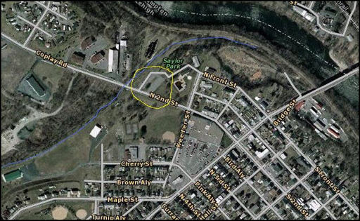
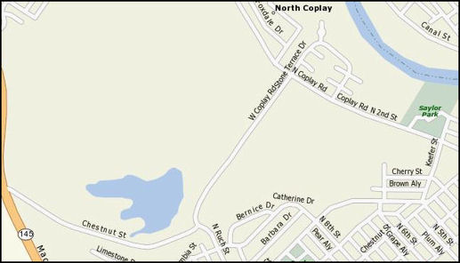
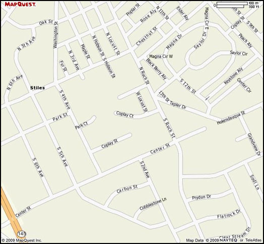
These directions are intended to circumvent all the traffic and crowds for the walk, but if you'd prefer you can go straight through Coplay... From Rt.145 (MacArthur Rd.) Past Center St. and Columbia St., turn right on Chestnut St. Follow it until it ends at a "T" and turn left, onto W. Coplay Rd. Turn right onto N. Coplay Rd (which becomes N. 2nd St.). The parking lot (circled in yellow on the map) is on the left, just after you cross over the old railroad tracks, which is part of the trail for the walk. We're to play on er, the tracks (the blue line), near something called the Kilns.
5K Run/Walk for the Race for Adam Foundation
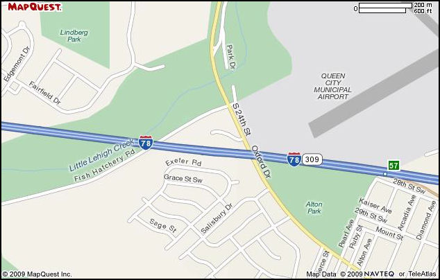
At the intersection of 24th St. and Fish Hatchery Rd., turn east, by the barn. Behind the barn is a parking lot, right next to the bridge.
It has been (rather snidely) pointed out that most band members probably know where the Allentown Fairgrounds are, and probably shouldn't drive if they don't. Please make sure of the route, however, as the St. Patrick's Day parade follows a different route, and does not require vehicles at the end for return trips. The Halloween parade begins at the Allentown Fairground and ends at the monument at 7th and Hamilton St. Parking for return vehicles at the end is in the Wachovia Bank parking lot, 7th and Hamilton.
Bloomsburg's 100th Anniversary and Fireman's Parade
 -
-  -
- 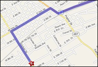
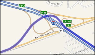
From the Allentown Fairgrounds, follow Tilghman St. west to the Pennsylvania Turnpike (TOLL) and head north to Rt. 80 (approximately 50 minutes). Follow Rt. 80 west for 36 miles (another aprox. 50 minutes). Take exit 241, Rt. 11 south, towards Berwick for 6.4 miles. Rt. 11 will also be called "New Berwick Highway", then the name will change to "Colombia Blvd.". When you get into Bloomsburg (providing they haven't shut all the streets down) turn right onto East St. (still 11 south). Turn left onto E. 5th St., then left again on Market St. Look for the Firehouse at 911 Market St. Bloomsburg, Pa. 17815.
 -
- 
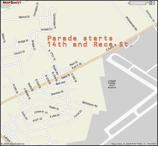
From Dieruff High School, follow Airport Rd. north past LVIA, turn left onto Race St. and circle around behind the airport. The first light in Catasauqua is N. 14th St. Turn right (if you are allowed). The parade forms up at Scheckler elementary, 201 N. 14th St.
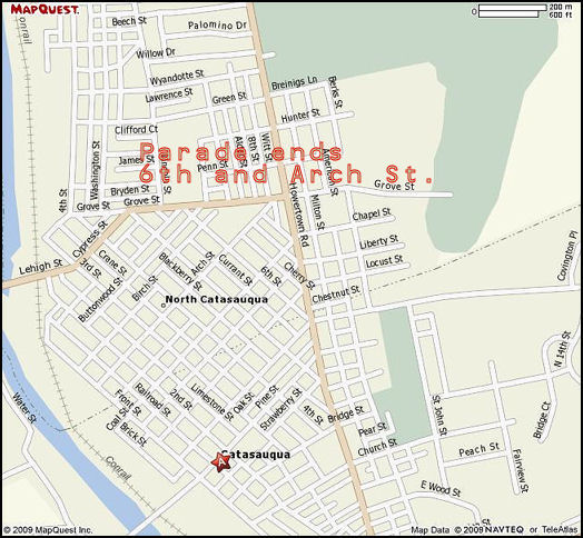
NOT A CIRCULAR PARADE ROUTE - To get to the parade route ending point: from Scheckler Elementary, follow 14th St. north to Walnut St. Turn left and follow Walnut to the 5-point intersection, and take a hard right turn onto Howertown Rd. Turn left onto 7th St and the parade route ending will be where 7th ends, at 7th and Arch St.
 -
- 
Our usual meeting place for this parade is at 11th and Chestnut St. From MacArthur Rd, take a right turn on Center St. Turn left onto Ruch St, then look for the alley on the right between Coplay St. and Chestnut St. Follow it one block to 11th St. A small parking lot is on the left, behind the "Elite Styling Salon". Park there if you want to leave your car at the start of the parade route. The parade runs down Chestnut St. to 2nd St., then turns right and ends at Hokendauqua St.
TO REACH THE END: From MacArthur Rd. turn right on Center St., then left onto Ruch St. Turn right onto Coplay St., than right again onto S. 12th St. Almost immediately you will have to turn left on Center St. (don't worry, you're getting there), and finally turn right on 5th St. We usually park around 5th & Schreiber Ave., which is across from the "Coplay Saengerbund". The parade people give out pretzles and sodas there, and your car will be nice and close.
 -
- 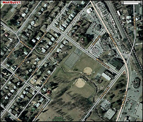
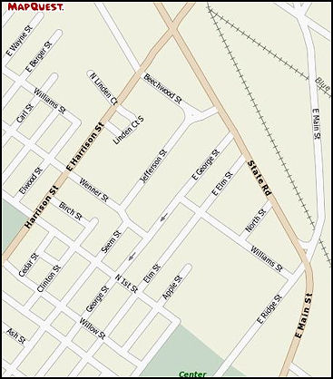
Heading from Allentown, take Lehigh St. south (west) towards Emmaus. Lehigh St becomes State Road as it nears Emmaus. Turn right onto North St., which dead ends at the tennis courts on Williams. If you're getting there closer to the parade the rent-a-cops will have closed State Road, so you must turn right onto E. Harrison St. The 6th left turn will be 1st St. Turn left, then left again onto Elm St. Williams St. is the next intersection, and the tennis courts will be visible on the right side. Park where ever available, we suggest sneaking onto one of the used car lots that front State Rd.
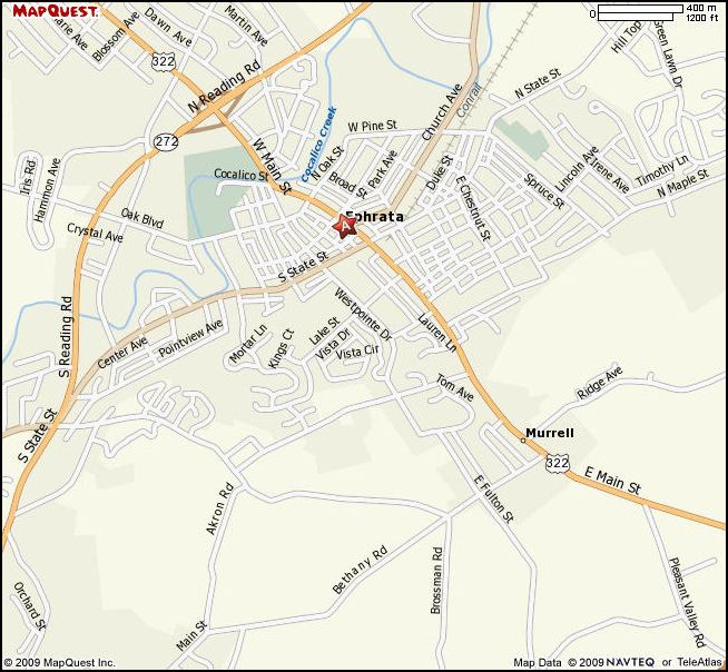
Take 222 West (or alternately the PA turnpike South, then West to exit 286. Turn right onto Rt. 322, which becomes Main St. Turn Left onto Oak St., which becomes Oak Blvd. The parade forms up at the High School, 803 Oak Blvd.
 -
- 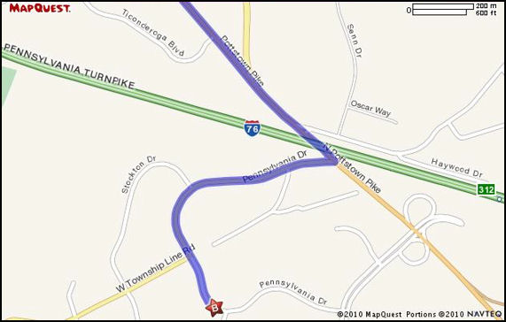
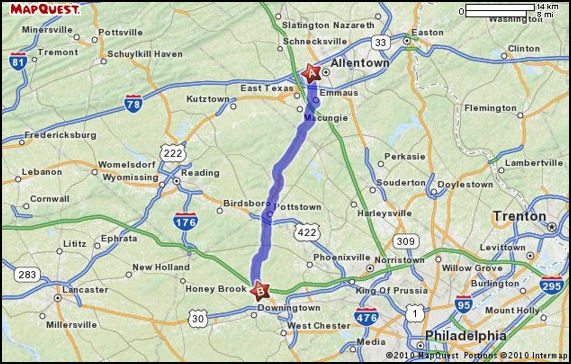
From Allentown take Cedar Crest Blvd. south to Emmaus. Follow signs onto Rt. 100 south. Follow 100 south for 35 miles, passing over (or under) Rt. 422 and Rt. 76. Just after passing Rt. 76 turn right on Pennsylvania Drive. The address is 720 Pennsylvania Drive, Exton PA 19341.

Turn right out of the Waffle House parking lot and follow 412 back towards Bethlehem's south side. At the split turn right on Shimersville Rd., then turn left over the bridge on Main St. Turn left onto Montroe St. and look for the elementary school at the top of the hill, on the right. The parade forms up at the school.
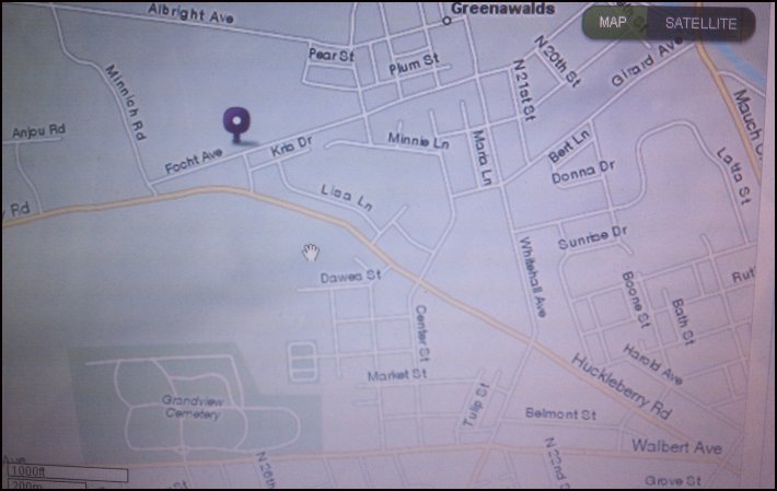
Starting at 19th & Walbert Ave, head west on Walbert Ave. to the fork in the road. Take Huckleberry Rd (the right hand fork) to Whitehall Ave. and turn right. Follow Whitehall Ave. to Focht Ave. and turn left. The fire station is on the right hand side, 2500 Focht Ave.
Girardville St. Patrick's Day Parade
 -
- 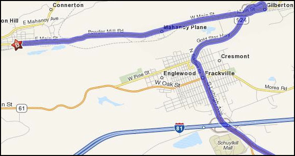
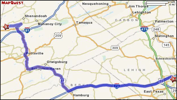
Take Route 22 west to Route 61, then go north, past Pottsville and over Rt. 81. Just north of the Rt. 81 interchange stay straight onto Lehigh Ave/PA-924, in Frackville. Stay on Rt. 924 north, for a mile and a half, then take the ramp toward Gilberton (map 2). At the end of the ramp merge onto A St., then turn right onto Main St. Main St. becomes Powder Mill Rd., then switches back to Main St. in Girardville. ***NOTE*** If you're arriving within three hours of the parade start time please be aware that the first thing they do is post some clown on Powder Mill Rd. to stop ALL traffic from entering Girardville via this route. Even though the parade starting point and parking for parade marchers is less then 300 yards away, you WILL be turned around to circle back to Frackville. SO.. if you're in any doubt be sure to turn left in Frackville onto Rt. 61 West (West Oak St.). Follow it for several miles until you reach a T-intersection in Ashville. Turn right onto Rt. 54 (West Center St.) and follow it into Girardville. You'll have to dodge hundreds of kids and people as you creep the entire length of town, but at least the 300 yards of wooded two lane east of town will remain safe.
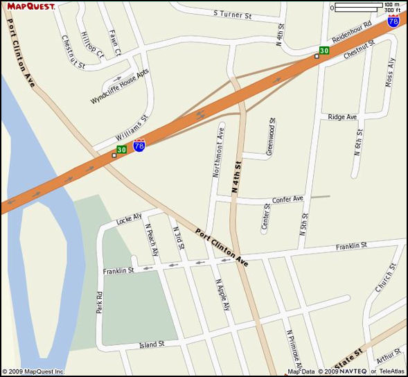
Follow Rt. 78 West to exit 30. At the end of the ramp take 4th St. south towards town. Aproximately 1/2 block past Confer Ave. turn left into the alley next to the Church. This alley will run two blocks and open out on to a field on the left. Park here. The parade forms up on Port Clinton Ave. and starts at the intersection of Port Clinton and 3rd St. It loops around and ends at Port Clinton and 4th St.
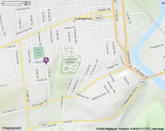
Take the Pennsylvania Turnpike north (toll) 1 exit, to Exit 74. Get in the left lane after the tollbooths to head south (or west) on Rt. 209. Stay straight on 209 over the bridge, turn right at the end of the bridge, then take the first left turn to stay on Bridge St. Follow Bridge St. to S. 7th St, and turn right. The meeting point is at the 8th St. Park.
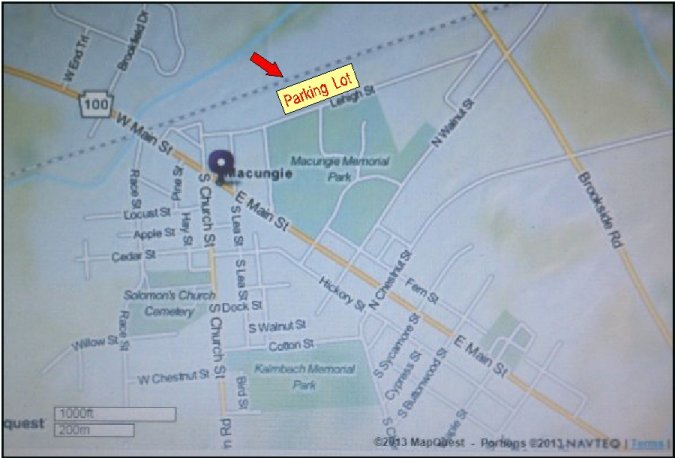
Macungie Halloween Parade
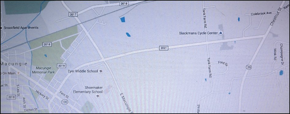
From Allentown you can take either Lehigh St into Emmaus, then get on Chestnut St at the Triangle. OR, you can take Cedar Crest Blvd. south until it ends at Chestnut St. and turn right. Follow Chestnut St. south until you reach Buckeye Rd. Turn right onto Buckeye Rd. and follow it straight, through Buckeye Pipe company's tank farm until you reach East Macungie Rd. Turn left, then right, into Eyer Middle School. The parade forms up on the other side of the school, in their lower parking lots. The end of the parade is somewhere in Macungie Memorial Park.
Take Rt. 22 west to PA 501/Lancaster Ave. South, exit 13 towards Bethel. Turn Left and then a Right on Rt. 501 for 8 miles. Take a Right onto W. Carpenter Avenue. Race St. will intersect W. Carpenter Ave. in about 1/2 of a mile. Look for parade officials to help you find parking.
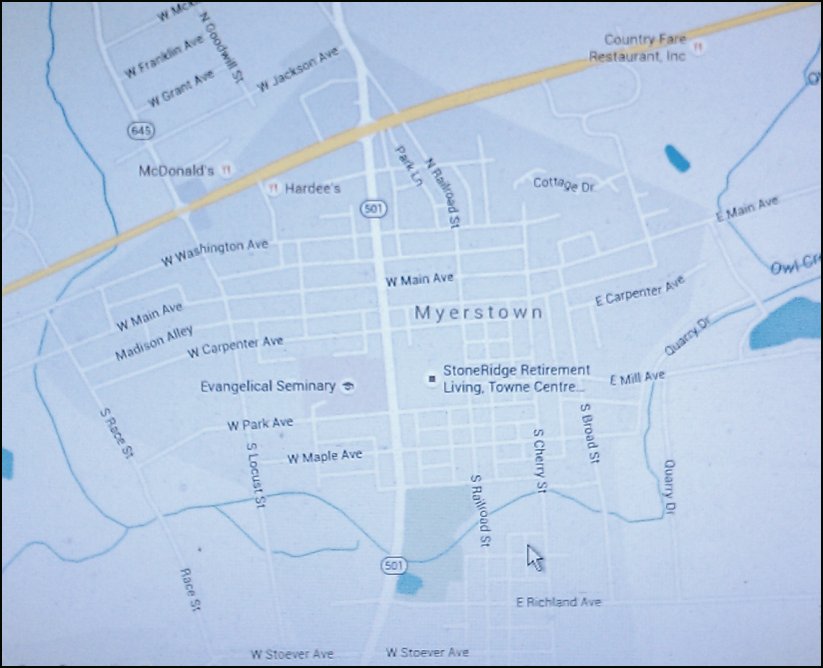
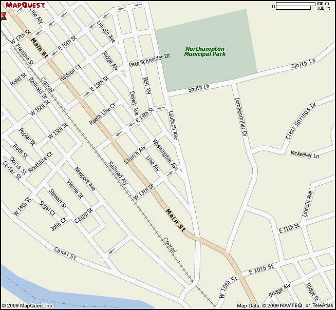
Head north from the meeting point at Wall Mart/Sam's Club on MacArthur Rd. to Main Street. Turn right, towards Cementon. Main St. becomes East 21st st. as it enters Northampton. Turn right onto Lauback Ave. Park in the Municipal building's parking lot, on the left, just past the school. The parade starts at the intersection of Smith Lane and Laubach Ave. It ends at the intersection of Main St. and Laubach Ave., just to the south of the starting point, so it will not be necessary to get vehicles to the end.
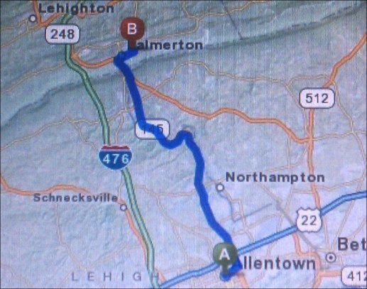
Head north on MacArthur Rd. (PA 145N) through Walnutport to PA 248W (Lehigh Dr.). Continue to follow PA 248 for aprox. 1.3 miles. Take the ramp toward Palmerton, then a slight right onto Delaware Ave. Look for 700 Delaware Avenue, just past 6th St. Look for a ballfield on the left. Parade officials will aid with parking.
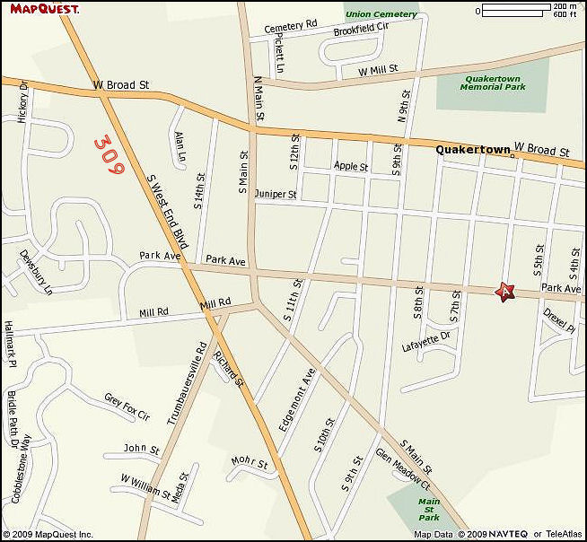
Follow 309 south, to Quakertown. Turn Left onto Park Ave, at the Dairy Queen. The High School is a few blocks up, on the right. The address is 600 Park Avenue.
Saucon Valley Halloween Parade
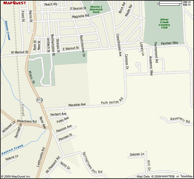
From Rt. 78 & Rt. 412, follow 412 (becomes Main St.) South into Hellertown. Turn left onto Macadoo Ave (becomes Polk Valley Rd) The school is on the left, at Campus Drive.
From Allentown follow MacArthur Rd (PA route 145) north through the gap. Turn left onto Rt. 946 (Main St) in Walnutport. Follow it through Walnutport and over the bridge into Slatington. Alternately, you can take the PA Turnpike, NE extention north 1 exit, then head south on route 209 towards Lehighton. Turn left onto Rt 248 just before the bridge, and follow 248 south the ramp for Rt. 873. Follow 873 over the bridge into Slatington.
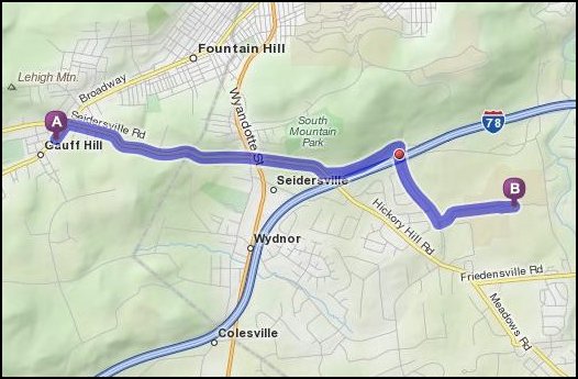
Starting on Emmaus Ave, go east to the triangle where Emmaus Ave. meets S. Fourth St. Turn left onto Seidersville Rd. Continue to follow it straight through the intersection at Rt. 378. Shortly after the 378 crossing Seidersville Rd. splits off to the left. Take the left and stay on Seidersville Rd. The next stop sign will be at Mountain Drive South. Turn right, and go under Rt. 78. Stabler arena will be on the left, on Goodman Dr.
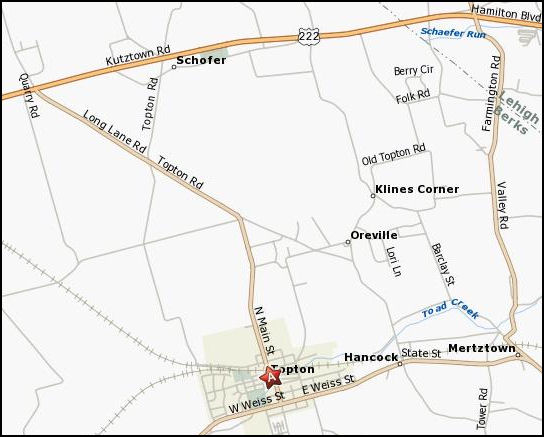
Take 222 West to Topton Rd, turn left and follow it into town. Just before entering Topton a policeman will stop all traffic and allow parade participants to enter the parking lot on Jefferson St.
From Chestnut St in Emmaus, turn on to South 10th St. and go under the tracks, then take the first right onto Pennsylvania Ave. Turn left at the fork in the road to stay on Pennsylvania Ave., the name will change to Quarry Drive North, then Vera Cruz Rd. Turn right on Main Road West, the parade officials will instruct you further.
Wheels of Time Car Show & Macunge Memorial Park
There are two ways to get to Macungie Memorial Park. 1) Head west on Hamilton Blvd. to Rt. 100 south. Follow 100 into Macungie. Rt. 100 becomes W. Main St. Look for Lumber St. or Poplar St. on the left. Depending on what is happening in the park you can turn left on one or the other. The park is immediately ahead.
2) Follow Cedar Crest Blvd. south to where it ends at Chestnut St. Turn right and follow Chestnut St. to the fork, at Buckeye Rd. (the Trivet restaurant sits at the fork). Turn right onto Buckeye Rd. and follow it into Macungie. Buckeye Rd. becomes Chestnut St. Turn right onto E. Main St. The second right wll be Poplar St. Turn right onto Poplar or the next road, Lumber St. (depending on traffic control). The park is straight ahead.
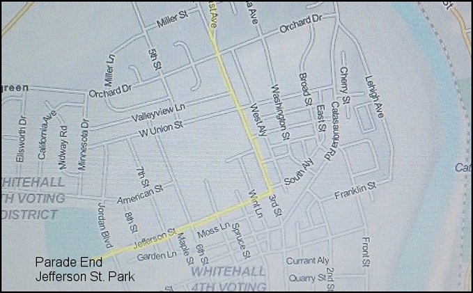
Whitehall's Fall Festival Parade
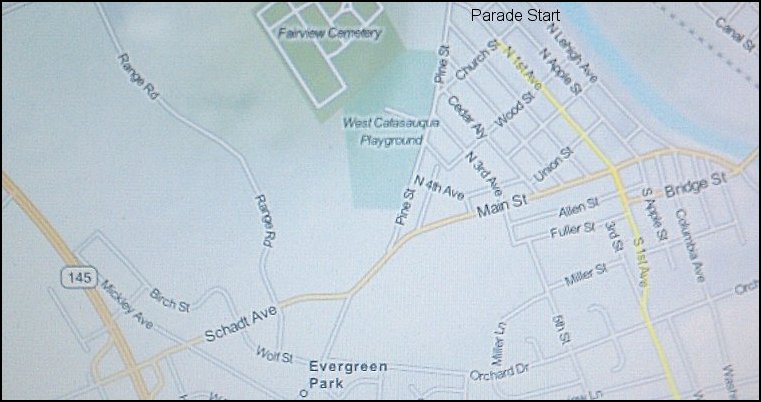
Head North on Macarthur Rd and turn right on Schadt Avenue. Follow Schadt until it forks, take the left fork onto Pine St. Park in the vicinity of the West Catasauqua Playground, or as close to 1st.Avenue & Church St. as possible. If you're meeting at the end, park in the Whitehall Mall parking lot, at the rear near the old Circuit City. The baseball field is part of the Jefferson St. Park.
This way to enter.net's Spotlite